drewkaree
Jetboaters Fleet Admiral 1*
- Messages
- 8,492
- Reaction score
- 31,506
- Points
- 847
- Location
- Central WI
- Boat Make
- Yamaha
- Year
- 2019
- Boat Model
- AR
- Boat Length
- 21
Sadly there are no charts for the lake (reservoir) we frequently use. They gave out a hazard map a few weeks ago, but no updated map this weekend and they never use buoys to mark hazards.
I'll pull the impeller housing off tomorrow and see what I find!
Thanks again everyone!
This is some info for you to check out, as I don't know if this is still good - it was with the last version I used...
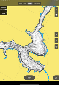
Navionics USED to (stating this, because it may have changed, no idea at this point) let you map your lake. I don't recall how it was, but you would fire up the app, and take slow passes in whatever fashion they mentioned, and you would be essentially doing the work that @FSH 210 Sport had available with the pre-existing maps that he was able to download. I'm certain that this method was/is how they plotted everything out, but since there's not anything available for your area, you'd be the mapper.
I don't know if there's an addition that needs to be downloaded, or if it's no longer available, or if it requires an even higher-cost add-on to the standard app. If you're boating there often, if it were me, I'd plot the areas surrounding the "problem" areas, so that you could give yourself a bigger area that you'd be aware of. I don't know if it could be ported to other formats, but from what I've seen, once you've got their maps, the water levels can be adjusted within the app, and it adjusts the entire lake layout for you based on the initial input. If that made sense, then you may want to look into it for future use.
Sorry for your troubles, but eventually you'll get on top of the issues, and you'll be all the more knowledgeable for it as well.


